West from Alice Springs: Three Gorges in Tjoritja
Larapinta Drive heads west from Alice Springs beside the long rock ridges of Tjoritja, the West MacDonnell Ranges. Water has cut through weak points in these ancient ranges, leaving gaps, sheltered creek beds and waterholes along the road.
West along the old ridges
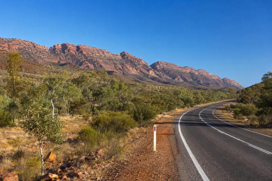 Larapinta Drive runs west from Alice Springs beside the long ridges of Tjoritja.
The drive begins with the geology underfoot. Strong currents laid quartz-rich sand in a shallow ancient sea, forming layers that later hardened into rock. During the Alice Springs Orogeny, pressure folded, fractured and lifted those layers. Erosion then stripped away much of the higher ground, while the hardest quartz-rich rock remained as ridges.
Rain and floodwater followed faults, fractures and other weak zones in those ridges. Over long periods, the flows cut the gaps and gorges that now break the ranges. Permanent and seasonal waterholes also support plants that struggle on the exposed slopes.
Tjoritja is the Arrernte name for the West MacDonnell Ranges. For Arrernte people, its waterholes, ridges and gaps form a cultural landscape shaped by ancestral beings, with names, stories and responsibilities tied to particular places.
The first stop lies only a short way beyond town.
Rungutjirpa at Simpsons Gap
At Simpsons Gap, known as Rungutjirpa, grassland and mulga give way to a narrow passage between steep rock walls. Old ghost gums stand near a permanent waterhole at the foot of the gap, and short paths run from the scrub towards the shaded bank.
The gap cuts through a weak zone in a resistant quartz-rich ridge. Its steep walls have lasted because the strongly cemented rock erodes more slowly than softer material nearby. The waterhole supports mulga, ghost gums and more than 40 rare plant species in the surrounding area. Black-footed rock-wallabies sometimes appear near the water around dawn or dusk.
People come here to walk, picnic and cycle. A paved cycle path from Alice Springs ends near the gorge, after which the approach continues on foot. Swimming is prohibited, so the waterhole remains a place to view from the bank.
That rule matters at Rungutjirpa. Several Dreaming paths and traditions meet at this spiritually important place, and a publicly shared account identifies it as the home of giant goanna ancestors. Staying on the path and leaving the pool undisturbed fits the use of a place where water, walking tracks and cultural knowledge meet.
Angkerle and its vertical walls
Farther west, Standley Chasm is known to its Western Arrernte custodians as Angkerle, or Angkerle Atwatye, meaning “Gap of Water”. The site stands beside the national park on land owned and managed by Western Arrernte through the Iwupataka Land Trust. Custodians have cared for this culturally significant place across generations.
The access path follows a creek bed beneath native gums. Springs and rain-fed pools support ferns, cycads and taller trees along the gorge floor, and birds gather around the water. Some plants in these protected creek environments remain from a wetter period, while the country beyond the gorge became far drier.
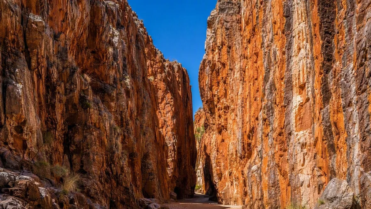
Angkerle shows the rock layers more plainly than Simpsons Gap. Dark and light bands rise almost vertically through the walls, and some surfaces retain ripple marks from the old sea. The layers began close to horizontal. Later compression tilted them, then rain and floodwater entered open fractures and enlarged the chasm.
A dolerite intrusion cut through the quartz-rich rock here about 800 million years ago. Later erosion removed almost all of that volcanic rock, leaving the deep, steep-sided passage. Around solar noon, direct sunlight reaches into the north–south chasm and picks out the red-orange walls and tilted bands.
Angkerle Atwatye is also an important Western Arrernte women’s cultural place, and some birth-site areas remain closed to men. Visitors use the designated access and path, avoid touching plants and animals, and leave no marks on the ground or rock. Local Aboriginal-guided walks offer cultural interpretation when available.
Practical details for the drive
Larapinta Drive reaches Simpsons Gap 18 kilometres, or about 20 minutes, west of Alice Springs. Namatjira Drive continues to Ormiston Gorge, 135 kilometres from town. Both roads are sealed, and visitors from outside the Northern Territory need an NT Parks Visitor Pass, from A$10 per adult for one day. Angkerle lies about 40 minutes from Alice Springs on a sealed road. Adult admission costs A$12; the site opens Monday to Saturday from 8am to 5pm and Sunday from 8am to 2pm, with earlier last-entry times. Tickets are sold online and on arrival. Day visitors do not need to book, but camping requires an advance booking. Check access before departure, as fire, high water or maintenance can close sites.
Kwartatuma and the waterhole at Ormiston Gorge
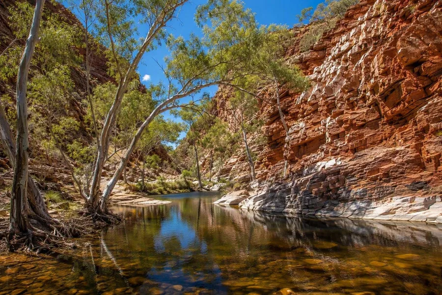 River red gums line the waterhole beneath folded quartzite walls at Ormiston Gorge.
Beyond Angkerle, the gaps lie farther apart and broader ground opens between the ridges. Kwartatuma, the Western Arrernte name for Ormiston Gorge, stands at the edge of Ormiston Pound, a broad basin enclosed by rocky ranges.
The rock shows the scale of the forces that formed Tjoritja. Thick beds of Heavitree quartzite have been folded, broken and pushed across one another. Pale quartz veins record fluid movement during that deformation. Water later used a weakened passage to cut the gorge through the ridge.
A nearly permanent waterhole lies inside the gorge. River red gums grow along the channel, while sheltered ground holds plant remnants from a much wetter past. The gorge also provided Western Arrernte people with food, hunting ground and shelter. A publicly shared Dreaming account tells of emus arriving from the east and a man hunting them at the waterhole.
Swimming is permitted here when conditions allow, unlike at Rungutjirpa. The water can be very cold and deep, with submerged rocks and timber, so swimmers should not jump or dive. A short, mostly paved Waterhole Walk reaches the pool. The longer Pound Walk crosses rocky slopes, descends to the flatter basin floor, then returns through the gorge. Ripple-marked rocks beside the paths preserve traces of the shallow sea that once covered this part of Central Australia.
The path returns to the waterhole beneath folded quartzite walls. Cold water fills the channel below river red gums rooted at the gorge floor.
Keep exploring