
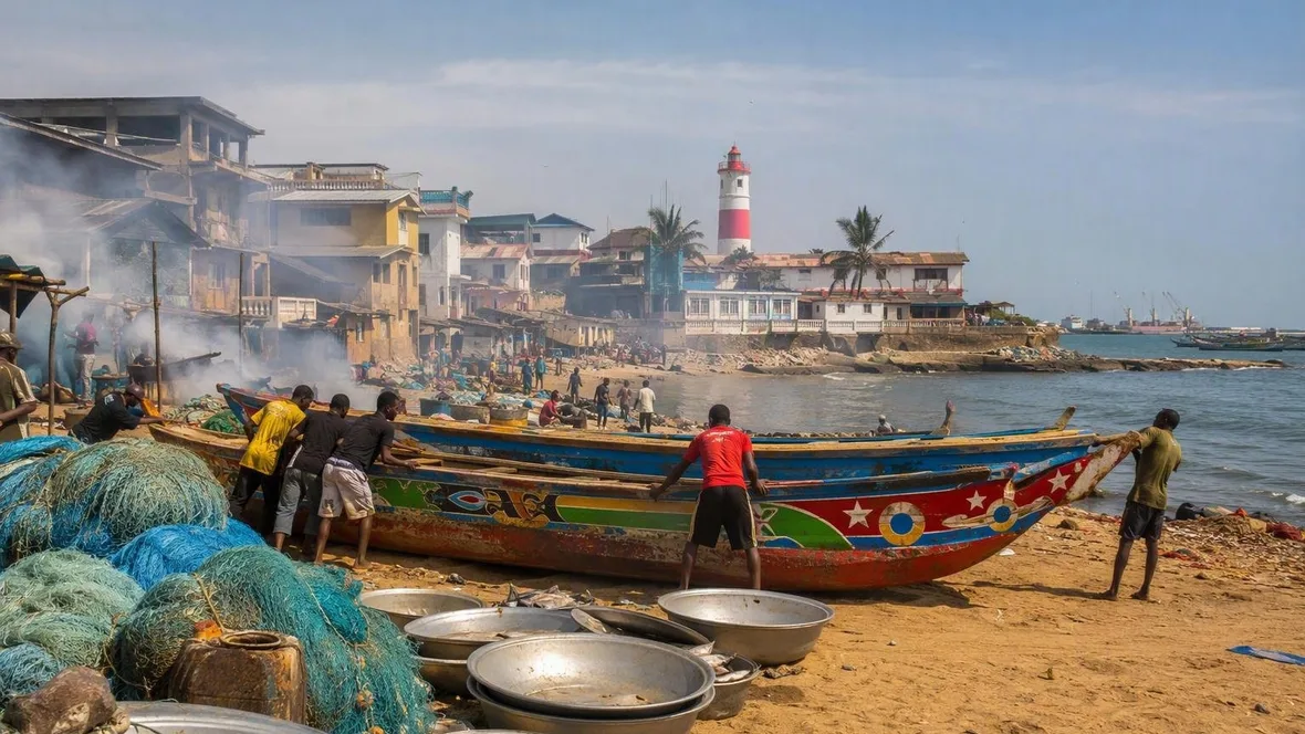
Morning between High Street and the harbour
In Jamestown, the morning runs downhill. School uniforms pass along High Street above the coast; below the red-and-white lighthouse, painted wooden canoes, metal pans and folds of net mark the short distance between the neighbourhood and the water.
Jamestown does not stretch along an untouched sweep of beach. The old canoe landing bay and waterfront were demolished in 2022 during construction of the new fishing harbour, changing the shore where boats, homes, small businesses and street life had long stood together.
That change matters at daybreak. It keeps the morning from becoming a postcard of an old bay. The coast now carries the hard lines of the harbour alongside the familiar materials of Jamestown fishing: painted wood, damp mesh, firewood, fish, metal and smoke.
Canoes return after hours at sea when the sun has barely risen. Other boats remain offshore. At the water’s edge, people pull a wooden hull towards land, shift fish from canoe to shore and draw netting clear of the boat.
The actions are plain. They give the shore its early shape.
Paddles knock against wood. Voices cross the waterfront, and broad metal fish pans clatter as hands move the catch from one place to another. Fish can still flap on the sand while people sort them into the pans.
The nets hold their own record of use. Blue mesh can turn pale under seawater and salt. Green netting gathers fish together, while loose pieces, worn bundles and older canoes lie close to the work.
Some people sit beside damaged net. Others stand over it. A needle-like tool and thread pass through a torn section, then through the next, until the mesh closes again.
This is a slower motion than landing a canoe. The net lies in long folds across the ground; hands work one small gap at a time.
Near the smoking ovens, stacks of firewood sit below metal. Fish smoking uses wood, fire, metal and smoke, and the smell of fish joins the salt air along the working shore. Smoke rises close to the district rather than at some distant industrial edge. For years, the foreshore also held homes, schools, places of worship, bars, businesses and a loose fish market. Canoe building, net making, repair and drying took place on the same strip beside the water.
The old landing bay is gone, but these materials still describe the human scale of the coast: a hull pulled in, a pan lifted, a net repaired, wood placed beneath an oven.
Above the harbour, the Jamestown Lighthouse rises in red-and-white bands. The tower stands over the low neighbourhood, with the Gulf of Guinea on one side and the coastal forts close by. Its slope provides the clearest physical passage between street and shore.
Narrow lanes run down towards the harbour from the built-up neighbourhood. They do not lead to a broad promenade. They descend through houses and walls to the sandy harbour edge, where wooden canoes have lain on the ground and people have repaired nets nearby.
Cleland Road runs near the lighthouse. High Street lies farther up, joined by Bank Lane, Bishop Lamaire Link and Lutterodt Street. The route is short, but every few steps change the materials underfoot and at eye level: asphalt and shopfronts above, masonry on the slope, then wood, rope and metal at the harbour.
James Fort stands on the harbour side. Ussher Fort retains its bastions and faces the sea. Their walls make a heavy contrast with a canoe’s painted timber and the loose, yielding mesh of a net. The forts hold the coast in stone; fishers handle wood and fibre below them.
Just beneath the lighthouse, a library serves an informal school for street children. Elsewhere, the morning school run takes clearer form on High Street. Holy Trinity Cathedral Senior High School occupies the cathedral courtyard directly beside this two-lane asphalt road.
Pupils in uniform have been photographed along High Street and on John Evans Atta Mills High Street near the Cathedral Clinic. The uniforms add sharp repeated shapes to the road: shirts, skirts and trousers moving past walls, shopfronts and the cathedral grounds. School traffic belongs as firmly to this morning as the clatter from the shore below.
High Street is not a waterfront boulevard. It carries neighbourhood traffic, shops and places to eat above the harbour. The sea sits nearby, but the road does not turn its back on the district to become a scenic strip. Buildings, side streets and the slope keep the water close without making it the only thing in view.
Around Crab Lane and Canoe Lane, murals colour walls among older colonial-era façades. The painted surfaces sit within the same compact district as the lighthouse bands, the fort walls and the colourful canoe hulls. Nothing here requires a long transfer. A lane, a slope and a few minutes on foot bring the street down to the harbour edge.
The harbour has altered that edge, and the former waterfront should not be treated as if it had remained fixed in place. Yet the ground still makes the relationship visible. Residential lanes descend. The lighthouse stands above them. James Fort and Ussher Fort hold their stone positions by the sea.
At the bottom of the slope, the street gives way to the harbour. A painted wooden canoe reaches the sand. Hands take the hull, while the metal pans, net bundles and smoke of the shore sit between the houses and the water.