Beyond the Gold-Rush Façades of Dawson City
At Dawson City’s waterfront, the Yukon River links a famous gold-rush town with a much older homeland. Wooden shopfronts survive, but Tr’ondëk Hwëch’in citizens still use, interpret and care for the river country that shaped life here long before miners arrived.
Dawson’s street grid ends at a broad river. Boardwalks, false-fronted shops and old warehouses stand on the low flat beside the Yukon; across the water, hills rise behind a channel that Tr’ondëk Hwëch’in people travelled for generations in skin boats, rafts and birchbark canoes.
The buildings make an easy gold-rush image. They do not tell the whole story. Dawson stands in the traditional homeland of the Hän-speaking Tr’ondëk Hwëch’in, whose river routes, fishing places, family territories and meeting grounds long predate the surveyed streets.
Before Dawson, there was Tr’ochëk
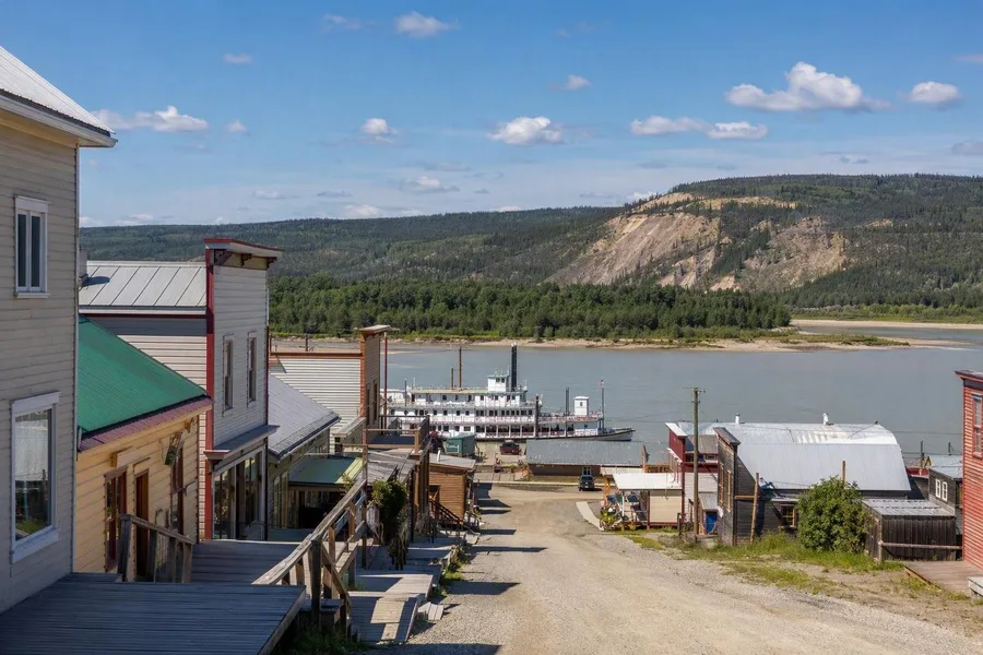 Wooden buildings and boardwalks on Front Street meet the Yukon River in Dawson City.
Just south of town, the Klondike River joins the Yukon at Tr’ochëk. Tr’ondëk Hwëch’in families gathered on this open river flat from midsummer into autumn to catch and dry fish, prepare hides, trade and lay in food for winter.
The nation’s name holds that relationship to the water. Tr’ondëk refers to the mouth of the Klondike River and recalls the hammerstones used to drive stakes for salmon weirs into the riverbed; Hwëch’in means people. The Yukon carried people and food, while its bends and tributaries held Hän place names and oral histories.
Gold changed access to this land with brutal speed. Prospectors found gold at Rabbit Creek, later renamed Bonanza Creek, in August 1896. By summer 1898, about 30,000 people had reached Dawson. Tents, log cabins and timber-frame buildings spread across the muddy flat, while shops, blacksmiths, dance halls and more than 300 businesses served the mining fields.
Miners and settlers forced the Tr’ondëk Hwëch’in from Tr’ochëk. Newcomers renamed the site Klondike City and built shops, saloons, tents and cabins over the seasonal fishing ground. Chief Isaac led the community downstream to Moosehide, its first year-round village from 1897. Families still travelled to fishing, hunting, trapping and berry-picking grounds, but the new town had taken a central gathering place.
Front Street and the working river
The waterfront became the loading bay for the boom. Sternwheelers landed passengers, food, tools and mining equipment, and warehouses lined Front Street. More than 250 paddle steamers travelled the fast, shallow Yukon until roads displaced this river traffic in the early 1950s.
Tr’ondëk Hwëch’in people also worked seasonally as deckhands, freight handlers and woodcutters for the steamboat trade, alongside fishing, hunting and trapping. The riverbank therefore held both a long-established Indigenous economy and the labour that sustained the goldfields.
The former British Yukon Navigation ticket office survives near the river. Its deep bracketed eaves belong to the only remaining waterfront building directly tied to Dawson’s freight and storage trade; it now serves travellers heading for the Dempster Highway. Nearby, the white sternwheeler S.S. Keno has been moored at the waterfront since 1960. These objects preserve the physical labour behind the familiar gold-rush image.
Dawson’s first boom faded quickly. Large companies bought many individual claims after the turn of the century, much of the population left, and Dawson continued as a mining service town. Preservation later kept its simple frame buildings, commercial façades and boardwalks standing.
Some of those buildings now carry a less comfortable history into present-day public life. The former Odd Fellows Hall belonged to a fraternity with a whites-only clause; it now houses the Klondike Institute of Art and Culture, with a gallery and performance space. In 2019, the Tr’ondëk Hwëch’in Elders Council named it Dënäkär Zho, or “house of mixed colours,” in response to that segregated past. The Yukon School of Visual Arts occupies another preserved commercial building, and students show work in its ground-floor Confluence Gallery.
Dänojà Zho faces the Yukon
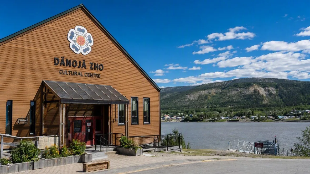
Dänojà Zho Cultural Centre breaks decisively with Dawson’s gold-rush architecture. The Tr’ondëk Hwëch’in opened the centre in 1998 and gave its contemporary form references to salmon-drying racks and winter shelters. Its name means “Long Ago House,” but its work concerns present-day community life as much as history.
Large windows look across the Yukon towards Moosehide Village. The centre hosts exhibitions, films, art, performances, riverside walks and gatherings, while the Hammerstone Gallery covers life before the stampeders, knowledge of the land and Tr’ondëk Hwëch’in leadership. Changing displays in the Gathering Room bring together family objects, photographs and films.
The programme also records cultural practices interrupted by colonisation without treating them as finished. A 2025 exhibition centred on the renewal of a tall potlatch hat and opened with Hän singing. Tr’ehude: Our Way brought together Tr’ondëk Hwëch’in artists addressing damage to land, animal loss and changing harvesting seasons. Workshops have combined sewing and clothing-making with Hän words, stories, ceremony and discussions of women’s roles.
Beadwork, handmade clothing, footwear, jewellery, books and music place current makers beside historical displays. This is not a prelude to Dawson’s story. Tr’ondëk Hwëch’in citizens live and work in town, and the nation has governed its own affairs and lands under agreements concluded in 1998.
The river still connects the settlements
Moosehide remains visible downstream from the cultural centre. The village has rows of buildings facing the river, shared spaces and smokehouses used for hanging and drying fish. Visitors can see it from the river corridor, but Moosehide itself generally opens to outsiders only during the biennial Moosehide Gathering.
Tr’ochëk has again become an active fishing camp for Tr’ondëk Hwëch’in citizens. Since 2023, Tr’ochëk, Moosehide, Dawson and other river sites have formed the Tr’ondëk-Klondike World Heritage Site, recognising both colonial gold extraction and the community’s continuing relationship with land and water.
The public waterfront remains a place of ordinary movement. Its trail, park and gathering spaces host walks, concerts and community events, while the free George Black Ferry carries pedestrians, cyclists and vehicles between Dawson and the west bank during the open-water season.
Practical details
Dänojà Zho stands at 1131 Front Street, opposite the Visitor Centre. Published summer hours are Monday to Saturday, 10am–5pm; winter visits require an appointment, and current admission prices should be confirmed with the centre. Drivers reach Dawson from Whitehorse on the North Klondike Highway, and flights connect through Whitehorse.
Arrival from the west bank
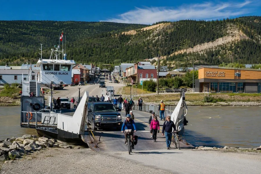 Passengers, bicycles and vehicles leave the George Black Ferry at Dawson’s Front Street landing.
The George Black Ferry crosses the Yukon without a bridge, carrying cars, bicycles and people in six or seven minutes. As the ramp reaches Dawson’s bank, the low wooden town sits beneath Midnight Dome and the pale scar of the Moosehide Slide. Front Street, Dänojà Zho and the river meet at the landing.
Keep exploring